Categories
Thailand

Thailand flooding update October 22, 2011: Map of northern’s Bangkok’s Prapa canal

Just a quick update as of 3 p.m. Bangkok time today, October 22, 2011:

New map

Some of yesterday’s news coverage focused on flooding caused by overflows from Prapa canal, in Bangkok’s north.

I wasn’t able to find many maps of the canal online yesterday, so I wanted to share this map, below, from today’s Bangkok Post:
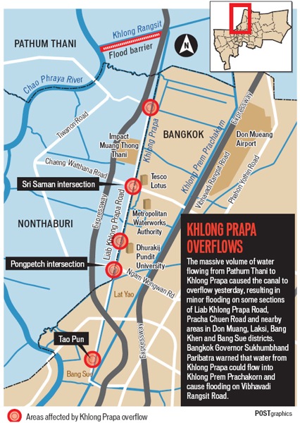
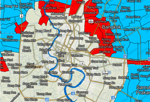
2011 10 22 thailand flooding prapa canal

The map shows, in red, the problem areas along the canal. This is the part of northern Bangkok and Nothaburi near Don Muang airport.

News reports

The WSJ has a look at the risks caused by urbanization:

Floodwaters started seeping into Bangkok Friday, as Thailand’s deepening flood crisis cast fresh light on the way rapid urbanization has increased risks for some of the developing world’s biggest cities, making them more vulnerable to natural disasters.

And:

But a rising chorus of experts says man-made factors have greatly exacerbated the problems—especially the growing concentration of people in vulnerable areas as Southeast Asia urbanizes.

In the middle of the last century, before Thailand became one of the world’s fastest-growing economies, fewer than a million people lived in Bangkok and less than 10% of the country was urbanized. Today, an estimated 12 million people live in the Bangkok metropolitan area, and more than a third of the country’s population lives in cities.

The NYT says:

Prime Minister Yingluck Shinawatra said Friday that she would take direct command of flood control in Thailand as Bangkok took the risky step of opening its floodgates and as criticism of the government mounted after days of disorganization and conflicting messages.

And:

“The real loss of the flooding is the loss of complete credibility of the Thai state in managing the kind of disaster that has occurred,” said Ammar Siamwalla, a prominent economist in Thailand who specializes in development issues.

“You must remember that this is a disaster in slow motion,” he said. “It has been accumulating, little by little, until it reaches Bangkok. It demonstrates a complete lack of infrastructure to handle the floods.”

(All emphasis mine.)

Reminder: You can read previous posts by clicking the Thailand flooding tag.

As ever, you can follow me on Twitter: @Newley.
Categories
Thailand

Thailand flooding update October 21, 2011: Building a flood barrier on Sukhumvit

Here’s the latest as of 9:30 p.m. Bangkok time today, October 21, 2011:

Summary

  • Flooding continues to affect northern Bangkok.
  • Central Bangkok is still under threat.

The situation on lower Sukhumvit

A week ago I posted a photo of sand bags on lower Sukhumvit.

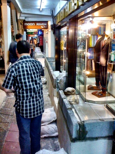
Just an hour or so ago, at the same location near Sukhumvit Soi 14 and the Asoke BTS station, I spotted workers erecting a wall to prevent potential flooding from hitting a tailor’s shop.

Here’s a cell phone pic, looking in the opposite direction as the earlier image:

2011 10 21 bangkok flooding wall

Note that this was only construction of flood walls I saw in the immediate area, so I don’t mean to suggest that this is a widespread practice in the lower Sukhumvit zone.

New maps

Here are two new maps I’ve come across:

Here’s an embedded map, below, showing photos of the flooding (click the icons for images):


ดู Thailand Flood photo 2011 ในแผนที่ขนาดใหญ่กว่า

And here’s a a map with videos of the flooding. Again, click the icons:


ดู Thailand Flood Map Video September – October 2011 ในแผนที่ขนาดใหญ่กว่า

Don’t forget that a collection of previous maps can be found by checking the Thailand flooding tag.

And here are the maps from my previous post.

News reports

The AP says today that:

Thailand’s prime minister urged Bangkok residents to get ready to move their belongings to higher ground Friday as the country’s worst floods in half a century began seeping into the capital’s outer districts.

The government has opened several key floodgates in a risky move to let built-up water flow through the canals toward the sea, and it’s not known how much the canals will overflow.

An Associated Press team Friday saw water entering homes in Bangkok’s northern Lak Si district, along the capital’s main Prapa canal. The water rose to knee-level in some places but damage so far was minor and not affecting Bangkok’s main business district.

The WSJ‘s Southeast Asia Real Time reports:

Thailand’s capital city woke up Thursday to an uncertain few days in which Bangkok’s anti-flood defenses will be given their toughest test yet.

Local newspapers spelled out the government’s latest plans for diverting the floodwaters away from the heart of the Thai economy, warning that some of the city’s eastern suburbs will be sacrificed to protect the inner core. Bangkok accounts for over 40% of Thailand’s economic output, and the spectacle of a widespread inundation there could also badly damage the country’s substantial tourism industry for months or even years to come.

And there are these sobering figures:

National leaders hope to drain some of the flood waters through some of the city’s canals. The Bangkok Post newspaper reported that more than 8 billion cubic meters of flood waters are flowing from the northern and central Thailand towards Bangkok, but the Chao Phraya River that flows through the center of the city can only divert around 200 million cubic meters a day. Diverting water through the city’s canals would help ease the burden on Chao Phraya.

Reuters has a rundown of the flooding numbers:

– 27 of Thailand’s 77 provinces are affected

– 4 million acres (1.6 million hectares) of land is flooded, an area roughly the size of Kuwait or Swaziland, or twice the size of Puerto Rico

– 342 people have been killed as a result of the floods

– 2.4 million people have been affected

Bloomberg has the latest on the business implications:

Apple Inc. (AAPL) and Toyota Motor Corp. (7203) are facing the worst supply disruptions since the March earthquake that crippled Japan, leading investors to scramble assessing the financial toll of the floods in Thailand.

An FT beyondbrics blog post says:

As central Bangkok residents brace for possible floods and many factories north of the Thai capital remain under two metres of water, investors are starting to ask whether the worst floods in 50 years will damage the country’s prospects as a major global manufacturing base.

AFP reports on the tourism angle:

Since deadly monsoon rains began three months ago, images of inundated Thai homes and frightened residents wading through water have appeared worldwide and dented the allure of the “Land of Smiles”, typically associated with sunshine.

Many would-be tourists are now putting off their visits to the kingdom, according to industry groups, in another major blow little more than a year after the capital was rocked by two months of deadly political unrest.

The Association of Thai Travel Agents (ATTA) reported new bookings have fallen by up to 70 percent compared to usual levels for the month, while Tourism Authority of Thailand deputy chief Sansern Ngaorungsi said cancellation rates had reached about 25 percent.

And finally, the Bangkok Post reports that:

Prime Minister Yingluck Shinawatra on Friday assumed powers under the natural disaster law giving her full authority to implement a nationwide disaster relief plan.

(All emphasis mine.)

Stay tuned.

As ever, you can follow me on Twitter: @Newley.
Categories
Thailand

Thailand flooding update October 20, 2011: New flooding maps, and details on threat to inner Bangkok

Here’s the latest as of 4 p.m. Bangkok time today, October 20, 2011:

Summary

  • Officials are now saying parts of inner Bangkok are under threat — while it had seemed a few days ago that the worst had passed.
  • Prime Minster Yingluck seems increasingly to be coming under pressure as critics question the government’s methods in dealing with the floodwaters.

New maps

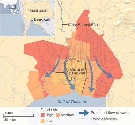
The BBC has this basic map today that shows which parts of Bangkok are most at risk:

2011 10 20 bangkok flooding map bbc

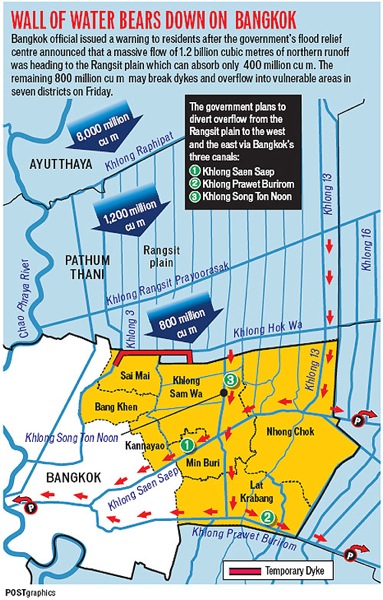
The Bangkok Post today has this map and an accompanying story:

2011 10 20 bangkok flood map bkk post

Meanwhile, this one, labeled Thailand Flood Monitoring System, provides additional information. Most of the site is in Thai, but the map is in English. Below is a screen capture:

2011 10 20 bangkok flooding map

The map is online here.

(Via @elgrodo.)

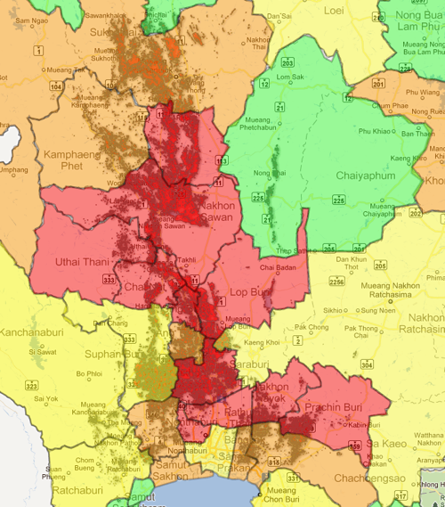
Here’s another map that seems to provide a visual representation of the parts of central Thailand and greater Bangkok that have been hit. Here’s a screen cap:

2011 10 20 thailand flooding map2

The map is online here.

(Via @seacorro)

News reports

The BBC has a good TV piece on how people are coping in hard-hit Ayutthaya. You can watch it online here.

Bloomberg reports mid-day today that:

Thailand’s government warned that floodwaters may reach parts of inner Bangkok, sending stocks and the baht lower as the government struggles to control a deluge that has inundated thousands of factories.

And there are these additional details:

The government earlier today warned residents living near Prapa canal, which runs from northern Bangkok to an area of the city near Victory Monument along an elevated train line, to be vigilant against floodwaters.

“If we can’t pump water out on time, there is a chance Bangkok may be swamped,” Pracha Promnog, head of the national flood center, said in a phone interview with Channel 3 today.

The AP reports:

Thailand’s new premier acknowledged the country’s flood crisis has overwhelmed her government, pleading for mercy from the media and solidarity from the country in battling the relentless waters.

In an emotional appearance before reporters Wednesday, Prime Minister Yingluck Shinawatra said her administration is doing all it can and trying to be as clear as possible about where the flooding may strike next.

The WSJ says:

Thailand’s Prime Minister Yingluck Shinawatra pleaded Wednesday for the country’s warring political factions to unite to combat a worsening flood crisis that now threatens to engulf parts of the capital.

Reuters says:

The threat of serious flooding in Bangkok is growing because of the volume of water running down from the centre of Thailand, and one inner city area was under threat on Thursday after floodwater breached a waterworks canal, officials said.

Pracha Promnok, justice minister and head of the government’s flood crisis centre, told Channel 3 television that city officials had been pumping water out overnight in the Samsen and Makkasan areas, which are just north of the royal palace and other sites visited by tourists.

(All emphasis mine.)

As a reminder, previous posts can be found by clicking on the Thailand flooding tag.

Stay tuned.

As ever, you can find me on Twitter: @Newley.
Categories
Thailand

Thailand flooding update October 19, 2011: Tips for tourists, a new map, and more

Here’s an update as of 11:30 a.m. today, October 19, 2011:

Tips for Tourists

I have received several emails from folks asking whether it’s still a good idea to visit to Thailand.

Obviously, I would not recommend tourists travel to central Thailand — and cities like Ayutthaya — since it’s been hard hit by flooding.

But as I’ve written here in my various Thailand flooding posts of late, central Bangkok has largely not been affected.

Other parts of the city, especially the north, have been hit by floods and are still at risk.

For other parts of Thailand, like the beaches in the south or Chiang Mai in the north, I suggest checking with the hotel or resort at which you’ll be staying. These areas have not been hit hard, but it can’t hurt to check and/or double check conditions on the ground.

So far, Bangkok’s international airport, Suvarnabhumi, has not been affected. But continue monitoring the news in case that changes.

I also suggest consulting official sources like the government’s Public Relations Department. Here is their announcement today.

And here’s is today’s statement from the Tourism Authority of Thailand.

And as always, other sources for updates include:

New Map

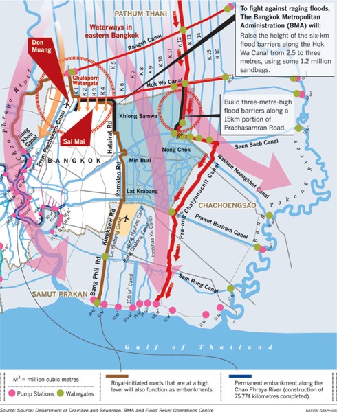
Today’s Nation has this map of Bangkok:

2011 10 19 bangkok flooding map

News Reports

Bloomberg reports today:

Thousands of volunteers bolstered floodwalls in Bangkok, boosting confidence among officials tasked with protecting Thailand’s capital from a surge of water that has shut factories and disrupted supply chains across Asia.

And the AP says:

Thai authorities were staging a fighting retreat Wednesday against flood waters that threaten Bangkok, after the country’s oldest factory park was completely inundated and a nearby one faced imminent threat.

Meanwhile, the WSJ has a story on Prime Minister Yingluck, the floods, and what one analyst calls a “leadership crisis”:

BANGKOK—Recriminations over the handling of Thailand’s worst floods in half a century are causing fresh setbacks for Prime Minister Yingluck Shinawatra as the financial cost of the disaster continues to mount and her government firmed up plans to inject billions of dollars to shore up the country’s faltering economy.

Ms. Yingluck’s biggest problem, analysts say, is the haphazard way information about the flood has been released, summed up by the science minister’s hasty call last week for evacuating part of the capital.

As ever, stay tuned.

Categories
Thailand

Thailand flooding update October 18, 2011: More info on industrial estates

Very briefly:

Today’s Bangkok Post has a story with a couple of new maps.

Here’s a satellite photo of Bangkok and central Thailand flooding:

2011 10 18 bangkok flooding

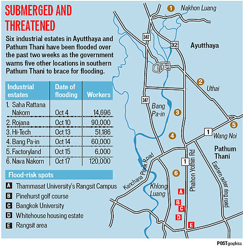
And here’s a map of the industrial estates that have been affected:

2011 10 18 flooding industrial estates

Meanwhile, the WSJ says today:

Damages from Thailand’s worst flooding in decades continued to mount as parts of another industrial estate were inundated and residents worried that Bangkok remained vulnerable despite recent receding waters.

And yesterday’s NYT reported:

Fortified by dikes, runoff channels and walls of sand bags, and with workers digging and dredging around the clock, Bangkok appeared on Monday to have withstood the worst of the slow-motion tsunami that has been bearing down on it in recent days from the flooded north.

The government’s PR department has an English language update with details on tourist destinations.

The Tourism Authority of Thailand has more.

Categories
Thailand

Thailand flooding update October 17, 2011: Bloomberg on ‘obsolete’ Thai weather radar

Quick note to point out an important story from Bloomberg today.

The headline is “‘Obsolete’ Thai Weather Radar Blamed for Failure to Predict Rain Severity.”

It begins:

Thailand’s weather service blamed obsolete equipment for failing to predict the severity of rains that killed 307 people, saying authorities ignored upgrade requests that could have mitigated the impact of flooding.

Requests from Thailand’s Meteorological Department for a 4 billion baht ($130 million) overhaul of its radar and modeling systems have gone unheeded since 2009, deputy director-general Somchai Baimoung said. The new equipment would allow the department to more accurately forecast seasonal rains, he said, giving dam operators information needed to adjust water levels.

“If we can get this new system, it can help people,” Somchai said in a phone interview yesterday. “No one expected rainfall would be this much. Right now our system, including hardware and software, is obsolete.”

Worth a read.

A recent BP post on Thailand’s dams is also worth checking out.

(All emphasis mine.)

(Bloomberg story via several folks on Twitter.)

Categories
Thailand

Thailand flooding update 2, Oct. 16, 2011: Is Bangkok in the clear?

Here’s the latest as of 11:45 p.m. today, October 16, 2011:

Overview

Reports suggest the worst may have passed here in central Bangkok, with no major flooding. (See news reports below.)

As I mentioned earlier, though, other parts of greater Bangkok — such as the north, west, and east — have been hit.

Ayutthaya and central Thailand have also faced major flooding.

Industrial estates in this part of the country have also been affected. (See below.)

More maps

Google Crisis Response has released an English language map. Below is a screen grab.

2011 10 16 thailand flooding

The map is online here.

This is a good resource, as it allows viewing different sets of data at once or individually.

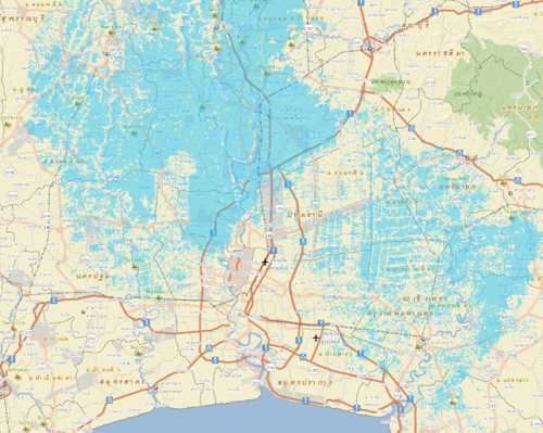
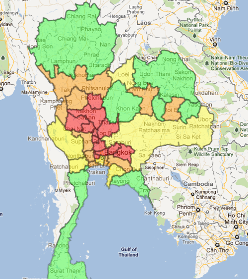
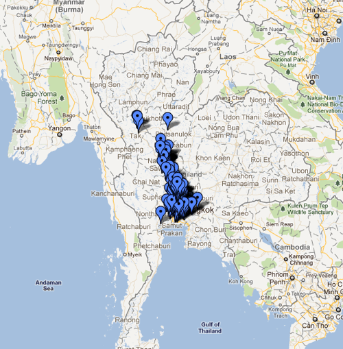
Here, for example, is the a map of the parts of Thailand that have been affected by floods:

2011 10 16 thailand flooding google map

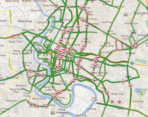
Traffy.in.th is a map that shows video from traffic Web cams. This could be useful for assessing road conditions.

Here’s what the map of Bangkok looks like. The camera icons can be clicked to see the videos.

2011 10 16 bangkok traffic map

The map is online here.

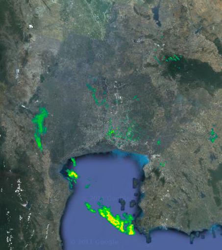
ThaiRainMap.com shows the portions of Thailand where rain is (or was recently?) falling.

Note that it’s unclear to me how this meterorological information is sourced. Here’s a screen grab:

2011 10 16 thailand rain map

The map is at ThaiRainMap.com.

News Reports

The AP says:

The government expressed confidence Sunday that Bangkok will escape Thailand’s worst flooding in decades, as the capital’s elaborate barriers held strong and floodwaters began receding from submerged plains to the north.

Agriculture Minister Theera Wongsamut said the largest mass of runoff water flowing southward had passed through Bangkok’s Chao Phraya river and into the Gulf of Thailand, and that the river’s levels would rise no higher. He stopped short of saying the threat to Bangkok had passed completely.

The BBC has more:

Thailand’s government has expressed confidence that the capital Bangkok will escape the worst of the country’s current flooding.

Agriculture Minister Theera Wongsamut said there were “good signs” that water levels on the city’s key Chao Phraya river would rise no higher.

The Bangkok Post reports that industrial estates have been affected:

Massive floods swamped a fourth major industrial estate in Ayutthaya yesterday, forcing authorities to order the evacuation of workers.

Water breached floodwalls to inundate Bang Pa-in Industrial Estate despite the efforts of the army and factory workers to reinforce defences.

Bang Pa-in district chief Nathee Borsuwan said people were ordered to move immediately to safe ground.

The water level was recorded at 80cm to one metre.

Soldiers and workers had raced to repair a broken floodwall on the eastern side of the estate since early on Friday but failed due to the strong flow of water.

Since the Chao Phraya River overflowed and burst a dyke at Wat Chaiwattanaram on Oct 4, Ayutthaya and downstream areas have been inundated. The Saha Rattana Nakorn, Rojana and Hi-Tech industrial estates were flooded, causing billions of baht of damage.

PBS NewsHour has a transcript from an Oct. 14 show about the flooding. Here’s a passage that caught my eye.

I was wondering if someone might reference Bush and Katrina:

CATHARIN DALPINO: Well, this is really a test for the new prime minister, for Prime Minister Yingluck, the kind of test that the Bush administration had with Hurricane Katrina, that the Japanese government had with the tsunami and the earthquake.

And every government on this planet, with the possible exception of one or two, now operates under performance legitimacy. How well do they do in these kinds of natural disasters? Certainly, in the past five years, Thailand has been very divided politically. It’s interesting in the past couple of days to see the bipartisan spirit or the multi-partisan spirit.

Yesterday, former Prime Minister Abhisit made a call upon Prime Minister Yingluck. He of course was her rival and he was the one that she turned out in the election. And that was a very, very important symbol.

(All emphasis mine.)

For ongoing info, I suggest the Thai Travel News blog.

And a reminder: previous posts with maps, news reports, and more can be found by clicking the Thailand flooding tag.

That’s it for now. If you’ve sent me an email and I haven’t respond yet, please be patient.

Categories
Thailand

Thailand flooding update, Oct. 16, 2011

Here’s a quick update as of 10 a.m. Bangkok time today, October 16, 2011:

Remember that all past posts — including maps, links to news stories, etc. — can be found by clicking the Thailand flooding tag.

I’m a bit pressed for time, but briefly:

People have written in asking about central Bangkok. What I wrote earlier still holds: Ayutthaya and central Thailand have been hardest hit, and western, northern, and eastern Bangkok are at risk.

Central Bangkok, for the most part, is still dry — from what I’ve seen.

While I’ve noticed that some shops and hotels have erected sandbag defenses here in central Bangkok, I have not seen any major flooding issues for now.

The U.S. embassy in Bangkok has some tips for dealing with the floods.

And their flood information page — especially the maps page — has links to some good resources.

Here are some news reports:

Bloomberg has an overview as of this morning:

Thailand moved to protect the capital, Bangkok, and the main international airport from flood waters as Prime Minister Yingluck Shinawatra said 10 provinces are still at “critical risk” after being inundated.

And there’s this, on the affect on Thailand’s industrial estates:

Yingluck said the situation remains “critical” in 10 of the 26 provinces still affected by flooding. Floodwaters have swamped industrial estates in Ayutthaya province, 67 kilometers (42 miles) north of Bangkok, halting production at factories operated by Japanese manufacturers including Nikon Corp. and Pioneer Corp.

And the AP has this story from last night that provides a good summary of what’s up:

Beside a wall of white sandbags that has become a front line in Thailand’s battle to prevent an epic season of monsoon floods from reaching Bangkok, needlefish swim through knee-high water inside Sawat Taengon’s home.
On one side, a cloudy brown river pours through a canal diverting water around the Thai capital, just to the south. On the other side, homes just like his are unscathed. Whether floodwaters breach fortified barriers like these this weekend will decide whether Bangkok will be swamped or spared.
As of late Saturday at least, the alarmed metropolis of glass-walled condominiums and gilded Buddhist temples remained unscathed, and authorities were confident it would narrowly escape disaster.

More soon…

Categories
Thailand

Thailand flooding update 2, Oct. 14, 2011: Sandbags on lower Sukhumvit

5:30 p.m. Bangkok time, October 14, 2011:

As I have noted in my previous posts on the flooding here in Thailand, central Bangkok has so far been largely unaffected.

Since several people have emailed me to ask about this part of town, I thought I would share the cell phone pic below, which I snapped earlier this afternoon.

I noticed a few large puddles on one of the city’s main thoroughfares, Sukhumvit Rd., most likely due to the recent downpours.

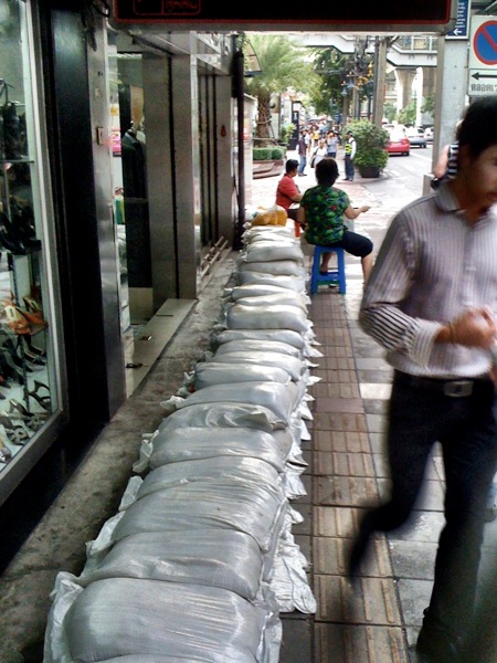
But I was somewhat surprised to see that near Sukhumvit Soi 14 and the Asoke BTS station, someone — likely merchants in the buildings on the left — had set up several sandbag barriers:

2011 10 14 sukhumvit sand bags

For the record: I spoke with a vendor who told me these were, indeed, meant to protect the area from potential flooding.

The sandbags weren’t meant meant, she said, to simply shield the shops from puddles that had already accumulated due to rain.

Again, I did not see any flooding along Sukhumvit, and have not seen any evidence of flooding in central Bangkok.

But as I’ve noted earlier, and as the maps I’ve posted show, other parts of the city — especially to the west, north, and east — have been affected and/or are at risk in the days to come.

As ever, I’ll continue sharing updates.

Categories
Thailand

Thailand flooding update, Oct. 14, 2011: more maps

Here’s the latest as of 12:30 p.m. today, Fri., October 14, 2011.

See my previous Thailand flooding posts for an overview of the situation. This brief dispatch will cover some new maps, as they seem hard to come by.

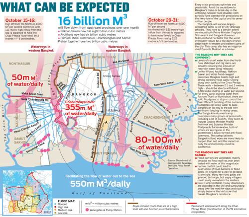
The Nation today has a detailed map, based on government data, of Bangkok areas that could be at risk in the weeks ahead:

2011 10 14 thailand flooding nation map

Here’s a bigger version.

The Google.org Crisis Response service has a map of Thailand displaying data from various sources. Here’s an embedded image, below.

2011 10 14 thailand floooding google maps

The clickable map is here.

On the right side of the map, you can choose to display various data sources.

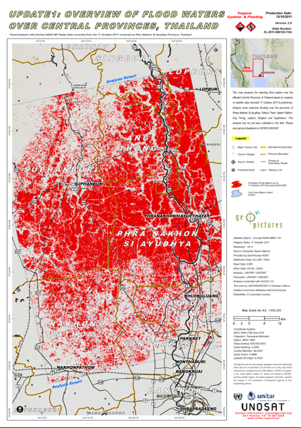
This led me to a detailed UN map showing flood waters in central Thailand as of Oct. 11.

Here’s a screen grab, below.

2011 10 14 thailand flooding UN map

The full 3.5 MB PDF file can be downloaded here.

Stay tuned. As ever, you can follow me on Twitter for more updates.