Categories
Thailand

Self promotion: New WSJ Southeast Asia Real Time story on “Roo Su Flood” videos

Quick note: I have a story on the Wall Street Journal‘s Southeast Asia Real Time blog today.

2011 11 01 whales3

It begins:

Victims of Thailand’s recent floods have complained for weeks that they lack a clear, reliable source of information as government officials issue conflicting reports about the disaster.

So many people are turning to other sources of information — especially a quirky animated video series that has become an online sensation by using lovable blue whales to explain Thailand’s hydrological troubles.

A screen grab of is above. Click the link above to see the full story and watch an embedded video.

Categories
Thailand

Thailand flooding update October 31, 2011: Yingluck says flooding shouldn’t worsen, but others warn Thonburi still at risk

Here’s the latest as of 6:30 p.m. today, Mon. October 31, 2011:

Summary

  • Prime Minister Yingluck said today that the flooding situation shouldn’t worsen, but Thonburi — western Bangkok — is still at risk.
  • Many of those who have been hit hardest by the floods in central Thailand and northern Bangkok are still in need of aid. (See Bangkok Post front page, below.)

New maps and images

Some new satellite images from a UN group show flooding along the Chao Phraya from northern to central Bangkok as of Oct. 24.

Below is a screen grab:

2011 10 31 unosat thailand flooding

The images are available here. A direct link to the (very large) PDF is here.

This map, below, from Longdo.com, allows users to zoom in and click on icons to see what appears to be footage from traffic cameras.

It’s a good way to get a sense of how things are looking in various parts of town.

A screen grab:

2011 10 31 thailand flooding longdo

And the map is online here.

Today’s Bangkok Post front page shows people in need of assistance:

2011 10 31 bkk post front page

(I cannot find an accompanying text story, however.)

News reports

The WSJ has this:

Floodwaters inundate the city. Businesses shut down and water-borne diseases spread. Families turn to boats rather than cars to get around.

This isn’t the latest update from Bangkok’s current flood scare — it’s from 1983, one of the many times that floodwaters have ravaged the Thai capital. Floods were so bad that year that 400 schools closed from October to early December and some areas didn’t dry out until after the New Year.

And:

Chris Baker, a Bangkok-based analyst and historian who has co-written several books about the country, said he recalls navigating Bangkok’s Sukhumvit Road — a thoroughfare for shopping and expatriate communities here — in a Thai “longtail” boat during the 1983 floods. He said his co-writer, Pasuk Phongpaichit, recalls playing every year in area floods as a child. “It was absolutely normal,” he said.

Bloomberg reports:

Hana Microelectronics Pcl is among the thousands of Thai companies with factories swamped by record floods calling on the government to help ensure it never happens again as waters slowly recede north of Bangkok.

Thailand’s credibility is on the line here,” said Hana Chief Executive Richard Han, whose Bangkok-based company makes parts used in digital music players and mobile phones. “A complete review of how to protect these industrial estates needs to be conducted and it needs government support.”

The AP says:

Thailand’s prime minister said Monday that she hopes the process of draining floodwater through Bangkok can be sped up now that peak high tides that saw the city’s main waterway rise to record levels have passed.

The Bangkok Post reports:

Prime Minister Yingluck Shinawatra says the flooding in Bangkok should not get any worse, but Science and Technology Minister Plodprasop Suraswadi said the west of Bangkok, Thon Buri, will see more flooding.

And:

Science and Technology Minister Plodprasop Suraswadi said that between 80 and 90 per cent of the Thon Buri side of the Chao Phraya River is certain to be flooded while the water is being drained more quickly through the western floodway.

(All emphasis mine.)

The standard reminders:

Administrative note

A reminder that going forward, I may not post every day.

I will continue to share major developments and useful resources, however.

Categories
Thailand

Thailand flooding update October 30, 2011: Authorities say things are improving

Here’s the latest as of 10 p.m. today, Sun. October 30, 2011:

Summary

  • Authorities said today that the worst may have passed, with the city’s flood defenses surviving this weekend’s high tides.
  • To re-cap the current situation: Northern, northwestern, and eastern Bangkok have been hit, as has central Thailand.

    Business, commercial, and tourist areas of central Bangkok — like Sukhumvit Rd., Silom, and Sathorn — remain dry.

    However, some areas near the Grand Palace and Chinatown have suffered minor flooding at times.

New map

Here’s a map that shows the flooding here in Thailand from Oct. 3 through Oct. 27:

2011 10 30 thailand flooding animatedgif

Click here to see it as an animated gif.

News reports

The NYT reports:

Shielded by hundreds of thousands of sandbags piled shoulder high along the city’s outskirts, most of Bangkok remained dry on Sunday, allaying fears for the time being that the massive metropolis would be swamped by monsoon floodwaters.

But along the flood walls, which ring the city and were being patrolled by soldiers and police officers around the clock, there was a mixture of relief and resentment.

And:

On Sunday, Ms. Yingluck said she was confident that the situation was improving because the flood walls were mostly holding up.

Experts and government officials said favorable weather and the passing of peak tides over the weekend might mean the worst was over for Bangkok.

“The situation is easing,” said Somsak Khaosuwan, the director of Thailand’s National Disaster Warning Center. “If the flood walls don’t break, inner Bangkok will definitely be safe.”

The AP says:

On one side of Bangkok, you’ll find the victims of Thailand’s worst flooding in half a century. They float down trash-strewn waterways, paddling washtubs with wicker brooms over submerged neighborhoods.

Just a few miles (kilometers) away, you’ll find something else entirely: well-heeled shoppers perusing bustling malls decorated with newly hung Halloween decorations, couples sipping espresso in the air-conditioned comfort of ultrachic cafes.

Although catastrophic flooding has devastated a third of this Southeast Asian nation and submerged some of the capital’s northernmost districts, the reality for the majority of this sprawling metropolis of 9 million people is that life goes on.

And AFP has some analysis:

[E]fforts to prepare the capital for looming floodwaters have been plagued by contradictory messages from Prime Minister Yingluck Shinawatra’s government and local authorities, both seeking to score political points, observers said.

The sense of disunity during the slow-motion catastrophe has doused hopes the crisis might bring rival political factions together following years of instability since royalist generals overthrew Yingluck’s brother in 2006.

This is no longer just an issue of natural disaster. It has become a ferocious political game,” said Pavin Chachavalpongpun, a Thailand expert at the Institute for Southeast Asian Studies in Singapore.

And finally, the Shutter Asia Web site has a forum post with some images and maps showing areas along the Chao Phraya that have been hit by minor flooding (scroll down).

(All emphasis mine.)

Travel advice

Again, I can’t reply to emails asking for travel tips. Sorry.

As I’ve said, things can change quickly and no one can accurately predict what the coming days and weeks have in store.

The standard reminders:

Administrative note

If, indeed, things are improving, I might not post every day going forward.

I will continue to share major developments, however.

Categories
Thailand

Thailand flooding update October 29, 2011: Bangkok’s flood defenses hold

Here’s the latest as of 9 p.m. today, Sat. October 29, 2011:

Summary

  • Inner Bangkok largely remains dry, but flooding continues to affect other parts of the city, especially in the north.
  • The Thai government was forced to move its flood relief operations away from Don Muang airport due to flooding there, but the Thai prime minister said today Thailand’s flood waters are beginning to recede.
  • High tides this weekend have pushed the Chao Phraya river to record levels. See below for some images I snapped today downtown.

Photos from the Chao Phraya today

Here are some cell phone pics I snapped at about 5:45 p.m. today along the Chao Phraya river near the Saphan Taksin BTS station:

No surprise here: the river was quite high.

Looking out from the BTS station:

2011 10 29 saphan taksin bts

Sathorn Pier:

2011 10 29 sathorn pier

And looking downstream:

2011 10 29 chao phraya high

I also encountered some flooding along Talad Noi, between Sathorn and Chinatown:

2011 10 29 talad noi flooding

Chinatown and the the area around the Grand Palace was largely dry.

Though there were sandbags piled in the Grand Palace’s doors, any recent flooding must have receded. I noticed a few large puddles one street nearby.

New maps

Here’s a good map, via Richard Barrow, of the current state of affairs.

It shows the city’s flooded areas and an assessment of the levels of risk for other areas:

2011 10 29 bangkok flooding map TEAM

Here’s a bigger version.

Meanwhile, thanks to reader J for sending along a link to some vivid images, below, from the National University of Singapore’s Centre for Remote Imaging, Sensing and Processing.

Here’s a screen grab from one image, which appears to show the flooding at Don Muang airport on Oct. 26:

2011 10 29 don muang flooding

The rest of the images are available here.

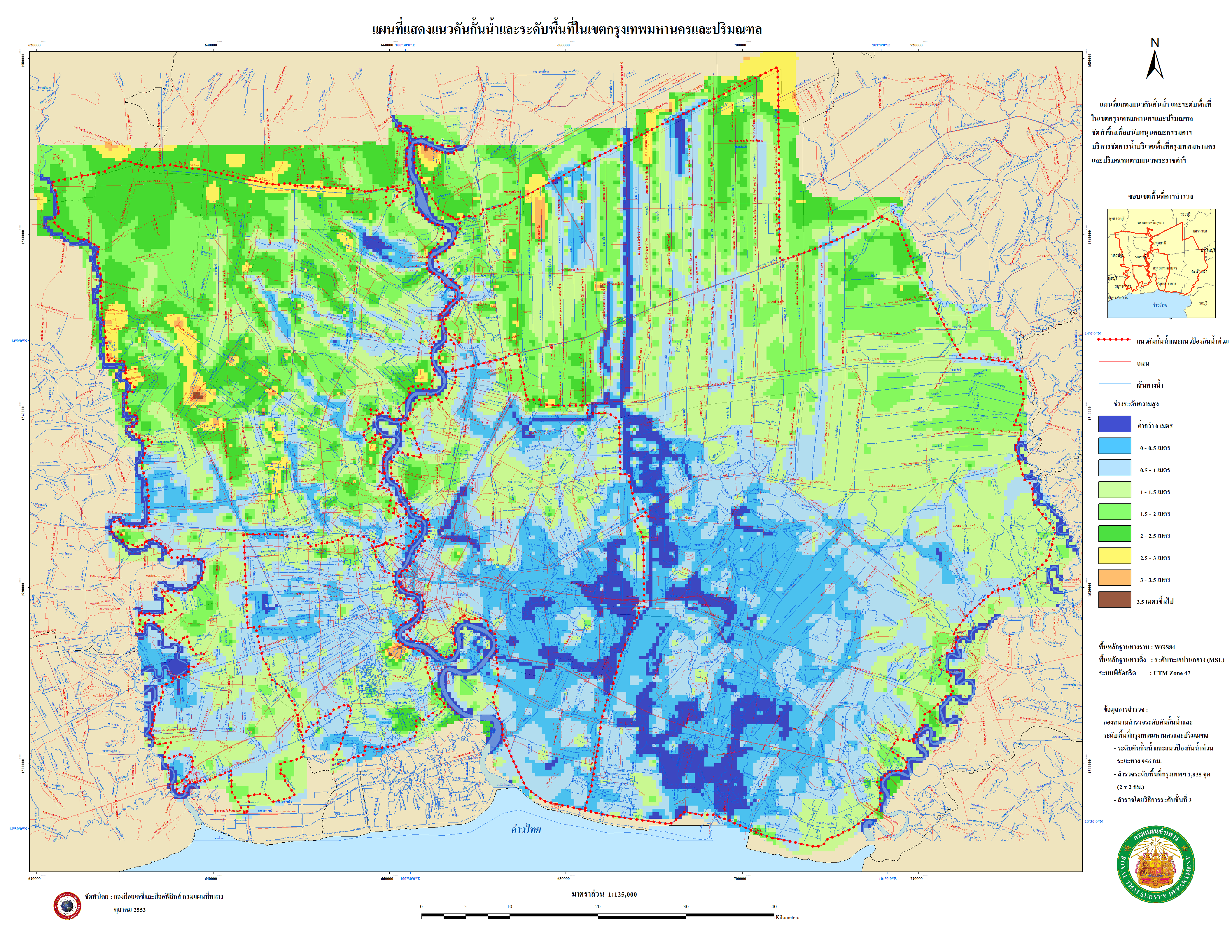
Elsewhere, Bangkok Pundit points out this map from Chulalongkorn Univ. that shows the elevations of Bangkok’s roads.

BP notes:

The two key factors that BP has been able to determine on which areas will flood are whether they are low-lying areas or not and whether they are near the Chao Phraya River and other canals. It is not an exact science. Whether you live near or close to the river and canals is usually fairly obvious, but how do you know whether you live in a low-lying area. The below map from Chulalongkorn University shows the elevation of all the roads in Bangkok:

2011 10 29 bangkok elevation flooding

A larger — and very large — image is here.

News reports

The AP reports:

Defenses shielding the center of Thailand’s capital from the worst floods in nearly 60 years mostly held at critical peak tides Saturday, but areas along the city’s outskirts remained submerged along with much of the countryside.

Prime Minister Yingluck Shinawatra said the floodwaters have started to recede after killing almost 400 people, submerging entire towns across the country’s heartland and shuttering hundreds of factories over the last two months. She urged citizens to let the crisis take its course as the floodwaters slowly drain to the sea, with Bangkok lying in their path.

The WSJ says:

Thai authorities abandoned their crisis operations center at Bangkok’s old international airport Saturday because of rising floodwaters as soldiers and volunteers raced against to time to shore up the city’s defenses against a massive flow of water that has already inundated parts of the capital and a vast swath of countryside.

Swelling high tides on the Chao Phraya River that winds through the heart of the city make this weekend critical. Rising water levels sweeping in from the Gulf of Thailand already are flooding riverside districts such as Bangkok’s Chinatown and making it difficult to channel floodwaters from upstream out to the ocean. The tides are expected to peak this weekend.

Reuters notes:

Receding floodwaters north of Bangkok have reduced the threat to the Thai capital, the prime minister said on Saturday, but high tides in the Gulf of Thailand will still test the city’s flood defenses.

“If things go on like this, we expect floodwater in Bangkok to recede within the first week of November,” Prime Minister Yingluck Shinawatra said on national television.

And finally, although it’s a few days old, here’s a characteristically excellent photo roundup of the Thailand floods from The Atlantic‘s In Focus blog.

Travel advice

To reiterate: I can’t answer emails and tweets asking for travel tips. Things can change quickly, and no one can predict exactly what will happen in the days and weeks ahead.

See my previous posts for links to a few articles with travel tips and resources.

The standard reminders:

Stay tuned, as ever.

Categories
Thailand

Thailand flooding update October 28, 2011: Minor flooding hits Grand Palace and outer reaches of Sukhumvit Rd.

Here’s the latest as of 10:30 p.m. Bangkok time today, Fri., October 28, 2011:

Summary

  • Flooding today hit downtown Bangkok’s Grand Palace and, briefly, the outer reaches of Sukhumvit Rd.’s Pra Khanong area.
  • It is still unclear, however, whether more of central Bangkok will be affected.

New maps

The United Nations Institute for Training and Research (UNITAR) has some new, highly detailed satellite images of the areas north of Bangkok.

You can find the files online here. (Note: The files are large.)

Below is a screen capture of part of one map:

2011 10 28 bkk flooding sat images

News reports

The AP reports:

Saffron-robed monks and soldiers piled sandbags outside Bangkok’s most treasured temples and palaces Friday as Thailand’s worst floods in decades sent ankle-high water rushing briefly into some of the capital’s main tourist districts.

High tides expected to peak on Saturday will be one of the biggest tests yet of Bangkok’s anti-flood defenses. For days, the city’s main Chao Phraya river has spilled its banks, forcing water into riverside streets from Chinatown to the white-walled royal Grand Palace and the neighboring Temple of the Emerald Buddha.

And:

New flooding was reported Friday in the city’s southeast when a canal overflowed in a neighborhood on the outer parts of Sukhumvit Road. And high tides briefly touched riverside areas closer to the city’s central business districts of Silom and Sathorn.

The NYT says:

The main river in Thailand’s capital swelled to a record high on Friday, spilling over its banks and sending water rippling into the grounds of the Grand Palace, with its temples and gilded spires, the city’s primary historical monument.

The amount of water entering the palace grounds was small, but the breach was symbolically significant as Bangkok enters a crucial period when high tides to the south are pushing back at runoff from the north that has breached the city’s outer defenses and is now flooding some outlying districts.

Bloomberg has this:

Bangkok’s Chao Phraya river swelled to a record high, swamping nearby tourist spots including the Grand Palace as Prime Minister Yingluck Shinawatra called for fresh ideas to stem the country’s worst floods since 1942.

And:

The government is considering cutting channels through five major Bangkok roads to drain floodwaters seeping into northern parts of the capital as a high tide threatens riverside communities. The roads, in the city’s east, are blocking water from reaching canals that drain into the Gulf of Thailand, Transport Minister Sukumpol Suwannatat said.

The WSJ‘s Southeast Asia Real Time reports:

Bangkok residents are continuing to grapple with shortages of water, bread and other basic necessities – and it might not get better anytime soon.

Retailers like 7-11, Tesco and Big C all rely on giant distribution centers to warehouse their goods, and many of them happen to be located in the heart of the flood zone, just north of Bangkok’s city limits.

The NBC News’s World Blog has a post about the mood here in Bangkok:

Bangkok on Thursday is rather like a slow motion disaster movie. But the bickering cast can’t quite agree on how its going to end. They keep putting up the end titles, only to follow with another, grimmer, scene.

There’s no continuity. If I were in a cinema, I’d walk right out.

Reuters has this story:

Traffic clogged roads out of the Thai capital on Friday as tens of thousands of people fled ahead of a high tide expected to worsen floods that have inundated factories and prompted foreign governments to warn their citizens to stay away.

Bangkok’s Chao Phraya River is expected to burst its banks over the weekend during the unusually high tide that begins on Friday, causing some flooding in nearby areas. Buildings across Bangkok have been sand-bagged for protection, and some vulnerable streets were nearly deserted.

Travel advice

Once again, I can’t answer emails and tweets asking for travel tips since things change quickly and no one can predict precisely what will happen in the days ahead.

However, I suggest travelers check out this CNNGo go piece with info for tourists.

The standard reminders:

Stay tuned for more.

Categories
Thailand

Thailand flooding update October 27, 2011: People increasingly leaving, but potential impact to central Bangkok still unclear

Here’s the latest as of 9 p.m. Bangkok time today, Thurs. October 27, 2011:

Summary

  • More and more people are evacuating Bangkok, with areas outside the city severely affected.
  • However, it is still unclear if, when, or to what extent central Bangkok will be hit.
  • Some reports say Bangkok officials have said the worst may be yet to come.

New maps

Thailand’s Geo-Informatics and Space Technology Development Agency (GISTDA) has this satellite image of water surrounding Bangkok.

The map is in Thai, and appears to be from Oct. 23. It paints a pretty clear picture of how much water has yet to be drained:

2011 10 27 bangkok flooding sat image

The original image is online here (warning: it’s a very large file).

More info and maps are available — in Thai — on the GISTDA site here.

Here’s another telling image from NASA’s Earth Observatory site.

The first image shows Bangkok two days ago, on Oct. 25th.

The second image shows what I take to be normal conditions:

2011 10 27 thailand flooding sat image nasa

More images are available online here.

News reports

The AP says:

Clamoring aboard bamboo rafts and army trucks, residents living on the heavily inundated outskirts of Bangkok fled waterlogged homes Thursday as floodwaters inched closer to the heart of the threatened Thai capital and foreign governments urged their citizens to avoid all but essential travel.

Bloomberg reports:

Matthew Lobner, head of Thai operations for HSBC Holdings Plc, lugged his furniture upstairs and moved his wife and three children near his office in downtown Bangkok to escape floodwaters on the city’s outskirts.

Lobner, drawing on his eight years as a naval submarine officer, stored enough food and water to last a month, along with a Nintendo Wii to keep his kids entertained. Europe’s biggest bank is giving all local employees the option of moving their families from areas threatened by flooding, he said.

Another Bloomberg story says:

Thailand’s government said it is losing the battle to protect Bangkok from rising floodwaters, and plans to open evacuation centers in eight provinces as the deluge forces more residents to give up their homes.

“The flooding is beyond our control now,” said Pracha Promnog, who heads the government’s flood relief operations. “The main wave of water hasn’t arrived in Bangkok yet.”

The WSJ’s Southeast Asia Real Time reports:

The lions, tigers, camels and giraffes can stay. The deer and chamois, though, must go.

That’s the word for now at the Dusit Zoo, a landmark in Bangkok’s leafy Dusit district, which is among the many parts of the city that have gone partly underwater amid Thailand’s worst floods in decades.

(All emphasis mine.)

The standard reminders:

Stay tuned for more.

Categories
Thailand

Thailand flooding update October 26, 2011: All of Bangkok is vulnerable, says Bangkok governor

Here’s the latest as of 8 p.m. Bangkok time today, Wed. October 26, 2011:

Summary

  • Bangkok’s governor said today that all of Bangkok could be hit by flooding. According to an official news agency, he said a large amount of water could arrive tonight (Wed. night).

    The governor reportedly said areas along the Chao Phraya river and in Bangkok’s north and east are especially vulnerable. (See MCOT story below.)

  • Bangkok residents are increasingly leaving the city and building their own flood defenses. (See AP story below.)

New map

Today’s Bangkok Post has an English language version of the “worst case scenario” flooding map I mentioned yesterday:

2011 10 26 bangkok floods wcs

Here’s a slightly bigger version.

News reports

The official MCOT reports:

Bangkok governor Sukhumbhand Paribatra on Wednesday warned city dwellers in all 50 districts to brace for flooding as a significant portion of the backed up floodwater from the North is arriving the capital tonight.

The governor made the announcement as he inspected the water level in Chao Phraya River, which he said is likely to be at 2.40 metres above mean sea level.

Mr Sukhumbhand alerted the public that floodwater from the North is also arriving Bangkok Wednesday night, bringing the situation to a critical point.

The governor said he has instructed all 50 districts to be prepared for flooding and expressed concern for 13 specially at-risk areas along the Chao Phraya River, as well as districts in northern and eastern Bangkok, including Lad Krabang, Nong Chok, Min Buri, Khlong Sam Wa, Khan Na Yao, Bang Khen, Sai Mai, Don Mueang, Chatuchak, and Bang Sue.

The AP has this story:

Bangkok residents jammed bus stations and highways on Wednesday to flee the flood-threatened Thai capital, while others built cement walls to protect their shops or homes from advancing waters surging from the country’s flooded north.

The NYT reported yesterday:

Bangkok’s flood defenses continued to fall on Wednesday as floodwaters pressed farther into the city after forcing the closing of the domestic airport. Prime Minister Yingluck Shinawatra warned that there could be as much as five feet of flooding in some areas.

The NYT has this today:

Hundreds of inmates were evacuated from prisons around Bangkok on Wednesday, and residents stocked up on food or made plans to leave the city as officials warned of severe flooding throughout much of the capital in the coming days.

Reuters reports:

Floodwater swamped a new area of Thailand’s capital on Wednesday as some shops started rationing food and the prime minister warned that parts of Bangkok could be flooded for up to a month.

Residents of Bang Phlad, a riverside district some way from Bangkok’s three swamped northern districts, were told to urgently evacuate as floods hit the capital on a second front, deepening anxiety in the city of at least 12 million people, many of whom were expected to flee ahead of a special five-day holiday.

The WSJ‘s Southeast Asia Real Time says:

>Water-delivery companies have suspended operations because their filtration plants north of Bangkok have been swamped, while retailers posted notes apologizing for the lack of water on supermarket shelves. Other key supplies that are running low include rice, noodles, diapers, powdered milk and cat food.

(All emphasis mine.)

Travel advice

Finally, a word about travel advice. Many folks have written to me to ask whether they should travel to Thailand now or in days ahead.

I am unable to offer advice since things are changing quickly on the ground and no one can predict precisely what will happen next.

However, I would suggest checking out this post at the travel site TravelFish.org. It lists the current status of transportation systems in Thailand and suggests various travel options.

The standard reminders:

Stay tuned for more.

Categories
Thailand

Thailand flooding update October 25, 2011: Don Muang airport now affected, and a new “worst case scenario” map

Here’s the latest on the flooding here in Bangkok as of 3:30 p.m. today, October 25, 2011:

Summary

  • The domestic airport, Don Muang, has now been hit by flooding, affecting commercial flights. Suvarnabhumi, the international airport, is fine. (See AP story below.)
  • The government has declared Oct. 27-31 as a holiday to allow people to cope with floods. (See Reuters story below.)
  • A Thai-language “worst case scenario” Bangkok flooding map appeared last night in the Bangkok Post and has been doing the rounds online.

    It seems to indicate that if all flooding defenses fail, floodwaters could reach 20-100 cm (7-49 inches) for parts of of central Bangkok. (See third map below, along with my caveat.)

New maps

Today’s Bangkok Post has a new map today of Bangkok’s affected areas:

2011 10 25 thailand flooding bkk post

The BBC has a map, below, showing affected areas, the predicted flow of water, and flood defenses:

2011 10 25 bangkok flooding bbc map

And the map below has been doing the rounds online. It comes from a Bangkok Post item from last night quoting “Dr Seri Suprathit, a water expert who tours affected flood areas every day…”

The Post reports: “In a live TPBS telecast, Dr Seri projected that if all the government’s flood defence walls including those protecting inner Bangkok were breached, Bangkok will surely be innundated as high as chest deep in some areas.”

2011 10 25 bangkok flooding worst case

Here’s a larger version.

Regarding the colors on the map, the Post says: “Yellow 10-20 cm; Brown 21-50 cm; Blue 51-100 cm; Green 1-2 metres.”

If my estimation is right, this could mean floodwaters reaching 20-100 cm (7-49 inches) for parts of central Bangkok.

Caveat: This is, of course, just one expert’s opinion. I would like to see other authorities weigh in on this prediction, as well.

And finally, CNN had a report about Thailand flooding earlier today that featured a satellite image of floodwaters and Bangkok. Here’s a cell phone pic:

IMG 0498

News reports

The AP has more info on the flooding at Don Muang airport:

Thailand’s flood crisis deepened Tuesday after floodwaters breached barriers protecting Bangkok’s second airport, effectively forcing a halt to commercial flights there after airlines using it suspended operations.

It was not immediately clear how much water had entered Don Muang airport. But the news was sure to further erode the credibility of a government that has repeatedly sent mixed signals about its ability to defend the heart of an increasingly anxious capital from the worst floods to hit Thailand in nearly 60 years.

Bangkok’s Suvarnabhumi Airport, the country’s main international gateway, has yet to be affected by flooding and flights there were operating normally. Most of the city has been spared inundation so far.

Reuters says:

Thailand announced a five-day holiday on Tuesday to give people to the chance to escape floods closing in on Bangkok as authorities ordered the immediate evacuation of a housing estate on the outskirts of the city after a protection wall gave way.

The cabinet declared Oct. 27-31 a holiday in Bangkok and 20 other provinces affected by the country’s worst flooding in 50 years as high tides in the Gulf of Thailand this weekend could complicate efforts to divert water away from the low-lying capital.

The WSJ reports on the economic impact:

Bangkok’s city leaders warned that a widening swath of the Thai capital is now under threat from fast-rising flood waters, while the economic impact of the crisis continued to ripple outward after Toyota Motor Co. said it would adjust production at some of its Japan plants because of the shortage of Thai-made parts.

And finally, the AP has a look at urbanization and Bangkok’s watery past — and present — that helps put the recent events in perspective. It starts:

As millions of urbanites living a modern lifestyle fear that torrents of floodwater will rage through Thailand’s capital, some in enclaves of a bygone era watch the rising waters with hardly a worry — they live in old-fashioned houses perched on stilts with boats rather than cars parked outside.

(All emphasis mine.)

The standard reminders:

Stay tuned for more.

Categories
Thailand

Thailand flooding update October 24, 2011: Warning issued last night for more areas of northern Bangkok

Here’s an update as of 8 p.m. Bangkok time today, Mon. October 24, 2011:

Summary

  • Last night the Bangkok governor announced that a new area of Bangkok’s north is now under threat. This includes Don Mueang airport, the area near Chatuchak Weekend Market, and more. (See news stories below.)
  • Bloomberg reports that two nights ago, armed men prevented workers from constructing flood defenses in an area north of Bangkok. (More info below.)

New photo

Workers at businesses throughout the city — even in central Bangkok, which is not now thought to be at risk — continue to erect barriers to prevent potential floods.

Here’s a cell phone pic I snapped today of a sand band fortification outside a shopping center in the downtown Silom area:

2011 10 24 silom sandbags

New maps

Here are a couple of new maps I’ve come across.

This English language map shows the levels of elevation throughout Bangkok. It also shows flood barriers and canals:

2011 10 24 bangkok flooding map elevation

(Map via @bkkbase and available as a larger image online here.)

The map above may be based on this Thai-language map:

2011 10 24 thailand flooding elevation

A bigger version is online here.

News reports

The Bangkok Post has a brief item on the areas of northern Bangkok that are now at risk:

Bangkok Metropolitan Administration late Sunday night issued a warning for people in six districts to prepare for flooding as the huge flow of foodwater from the North continues its creep into the capital.

The six districts are Don Mueang, Lasksi, Bang Khen, Chatuchak, Bang Sue and Sai Mai.

The AP has details on the Bangkok governor’s announcement last night:

Bangkok Gov. Sukhumbhand Paribatra warned residents in a televised address late Sunday that a large volume of water was surging forward faster than expected and was threatening six districts as it moved closer to the city’s more developed areas, including the section near Chatuchuk weekend market, a popular shopping stop for tourists.

Sukhumbhand also said the waters were expected to swamp the Don Muang area just north of the city proper. The area is home to Bangkok’s old airport, which is now being used as headquarters for the anti-flood effort and a shelter for evacuees.

Bloomberg says:

Thai floodwaters spilled into northern Bangkok today after armed men stopped workers from building a sandbag levee and a water gate broke, elevating concerns the deluge will spread to inner parts of the capital.

And:

Two nights ago, “a few men with weapons” from areas north of the city where floodwaters are as high as three meters (10 feet) confronted Bangkok officials building a sandbag levee at a low-lying junction, spokesman Jate Sopitpongstorn said by phone today. The men destroyed the barrier, he said, allowing the water to flow from Pathum Thani province into Bangkok.

The WSJ has a story that touches on preventing floods in the future:

With Thailand’s leaders warning businesses and residents to expect massive floods to persist for at least another month, attention here now is turning to how this major global production hub can avert future crises—and whether it can revive the wetlands and forests that used to soak up past floods but which have now been given over to sprawling industrial estates and housing projects.

There’s also a good slideshow of flooding images.

(All emphasis mine.)

The standard reminders:

Stay tuned for more.

Categories
Thailand

Thailand flooding update October 23, 2011: A new time frame frame for recovery, and questions about Saen Saeb canal

Here’s a quick update as of 11 p.m. Bangkok time today, October 23, 2011:

Summary

  • Yesterday the government said the floods could last six weeks, but today said things could improve by early next month. (See AP story below.)
  • One news item reports that PM Yingluck says inner Bangkok is, indeed, at risk — and there are now questions about San Saeb canal, which runs through inner Bangkok, near Sukhumvit Rd. (See Bloomberg story below.)

See below for more on both of these items.

New photo

As many news reported have mentioned, some grocery stores in Bangkok have sold out of items like water, canned goods, instant noodles, etc.

Here’s a cell phone pic I snapped this afternoon at a shop in Silom. I think this aisle used to be stocked with baby food and diapers.

2011 10 23 bangkok grocery story

New map

Today’s Bangkok Post has a helpful map showing the parts of Bangkok that have been affected so far:

2011 10 23 bangkok flooding round up

News reports

The AP reports:

The threat that floodwaters will inundate Thailand’s capital could ease by early November as record-high levels in the river carrying torrents of water downstream from the country’s north begin to decline, authorities said Sunday.

Bangkok’s immediate prospects remain uncertain, however, as the front lines in battling the flood draw tighter around the city daily.

The relatively rosy longer term projection from the Flood Relief Operations Center came just a day after reports that Bangkok’s main Chao Phraya river was overflowing its banks and at its highest levels in seven years.

Read the whole thing for some evocative stories about how folks are coping with the floods.

And Bloomberg says:

Prime Minister Yingluck Shinawatra said Thailand’s worst flooding in 50 years may reach inner Bangkok, as a deluge from the north drains through the capital and threatens to overrun canals in the city center.

“Bangkokians will have some impact as water will flow through canals,” she told reporters today. “It is still unclear how long Bangkok people will be affected as there are many uncontrollable factors.”

Floodwaters throughout the capital may reach more than one meter (3.3 feet), she said in response to questions from reporters today. Yingluck expressed concern about water levels in Saen Saeb canal, which runs close to shopping centers such as Central World and Sukhumvit Road. The nation’s heaviest flooding in a half century has killed more than 300 people.

(All emphasis mine.)

Saen Saeb canal is used mainly for transportation and runs roughly east to west through Bangkok, next to the Jim Thompson House, the Central World shopping complex, and more.

More info on Saen Saeb can be found on its Wikipedia page.

Stay tuned for more.

The standard reminders: You can find past posts by clicking the Thailand flooding tag.

And you can follow me on Twitter for more: @Newley.