Here’s the latest on the flooding here in Bangkok as of 3:30 p.m. today, October 25, 2011:
Summary
- The domestic airport, Don Muang, has now been hit by flooding, affecting commercial flights. Suvarnabhumi, the international airport, is fine. (See AP story below.)
- The government has declared Oct. 27-31 as a holiday to allow people to cope with floods. (See Reuters story below.)
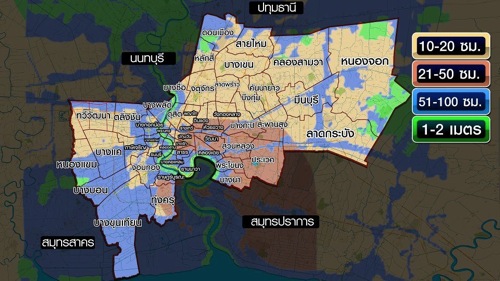
- A Thai-language “worst case scenario” Bangkok flooding map appeared last night in the Bangkok Post and has been doing the rounds online.
It seems to indicate that if all flooding defenses fail, floodwaters could reach 20-100 cm (7-49 inches) for parts of of central Bangkok. (See third map below, along with my caveat.)
New maps
Today’s Bangkok Post has a new map today of Bangkok’s affected areas:

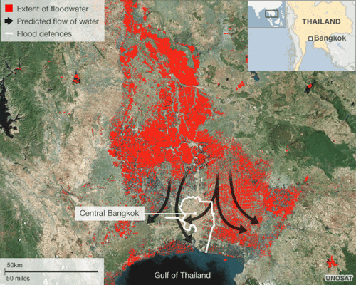
The BBC has a map, below, showing affected areas, the predicted flow of water, and flood defenses:

And the map below has been doing the rounds online. It comes from a Bangkok Post item from last night quoting “Dr Seri Suprathit, a water expert who tours affected flood areas every day…”
The Post reports: “In a live TPBS telecast, Dr Seri projected that if all the government’s flood defence walls including those protecting inner Bangkok were breached, Bangkok will surely be innundated as high as chest deep in some areas.”

Here’s a larger version.
Regarding the colors on the map, the Post says: “Yellow 10-20 cm; Brown 21-50 cm; Blue 51-100 cm; Green 1-2 metres.”
If my estimation is right, this could mean floodwaters reaching 20-100 cm (7-49 inches) for parts of central Bangkok.
Caveat: This is, of course, just one expert’s opinion. I would like to see other authorities weigh in on this prediction, as well.
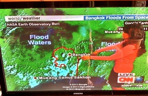
And finally, CNN had a report about Thailand flooding earlier today that featured a satellite image of floodwaters and Bangkok. Here’s a cell phone pic:

News reports
The AP has more info on the flooding at Don Muang airport:
Thailand’s flood crisis deepened Tuesday after floodwaters breached barriers protecting Bangkok’s second airport, effectively forcing a halt to commercial flights there after airlines using it suspended operations.
It was not immediately clear how much water had entered Don Muang airport. But the news was sure to further erode the credibility of a government that has repeatedly sent mixed signals about its ability to defend the heart of an increasingly anxious capital from the worst floods to hit Thailand in nearly 60 years.
Bangkok’s Suvarnabhumi Airport, the country’s main international gateway, has yet to be affected by flooding and flights there were operating normally. Most of the city has been spared inundation so far.
Reuters says:
Thailand announced a five-day holiday on Tuesday to give people to the chance to escape floods closing in on Bangkok as authorities ordered the immediate evacuation of a housing estate on the outskirts of the city after a protection wall gave way.
The cabinet declared Oct. 27-31 a holiday in Bangkok and 20 other provinces affected by the country’s worst flooding in 50 years as high tides in the Gulf of Thailand this weekend could complicate efforts to divert water away from the low-lying capital.
The WSJ reports on the economic impact:
Bangkok’s city leaders warned that a widening swath of the Thai capital is now under threat from fast-rising flood waters, while the economic impact of the crisis continued to ripple outward after Toyota Motor Co. said it would adjust production at some of its Japan plants because of the shortage of Thai-made parts.
And finally, the AP has a look at urbanization and Bangkok’s watery past — and present — that helps put the recent events in perspective. It starts:
As millions of urbanites living a modern lifestyle fear that torrents of floodwater will rage through Thailand’s capital, some in enclaves of a bygone era watch the rising waters with hardly a worry — they live in old-fashioned houses perched on stilts with boats rather than cars parked outside.
(All emphasis mine.)
The standard reminders:
- You can find past posts by clicking the Thailand flooding tag.
- You can follow me on Twitter for more: @Newley.
- You can connect with my Facebook page.
- And you can sign up for RSS updates, or join my email list.
Stay tuned for more.
4 replies on “Thailand flooding update October 25, 2011: Don Muang airport now affected, and a new “worst case scenario” map”
I visited Bangkok a few times in the early eighties. At that time I saw many of the scenic old khlong canals being covered over and replaced with concrete boulevards.
I have seen little comment in recent days regarding whether that is now regarded as having been a wise thing to do.
I also see mention of many flood control systems in the outer suburbs. But the central city still has few of the great levees and flood-walls that are so prominent in some other river-side cities that I have visited. I wonder if just perhaps the central govt should have spent a bit less on new airports and cross-river bridges and a just a bit more on central city flood control.
(A search reveals this interesting two-year old article on the long-term threat of flooding in Bangkok http://ipsnews.net/news.asp?idnews=49347).
I cannot read those sanskirt alphabetic as on 1st map any one can help me ?
Not Sanskrit.
I cannot read those alphabetic words as on 1st map