Note: Go to the home page or click the Hurricane Sandy tag for more recent posts.

Updated Sat. at 7:45 p.m.
Here are some resources for following Hurricane Sandy as it approaches New York City.
(Additional locations will also be affected by the hurricane and the accompanying “Frankenstorm,” of course. But I’ll be focusing on the metropolitan area since I’m here in uptown NYC.)
The latest:
- Mayor Bloomberg said residents should stock up on supplies now and stay out of city parks beginning tomorrow (Sunday) due to the possibility that high winds could cause tree limbs to fall, The New York Times says.
- The Tri-State area should see “rain and gusty winds” beginning tomorrow (Sun.) night, WNYC.org says.
- The New York Times‘s Lede Blog says “massive power failures are expected” in the Northeast.
- New York City’s subway, bus, and rail system remains open, though the Metropolitan Transportation Authority says it is preparing for a possible suspension that could begin tomorrow (Sunday) evening.
Maps

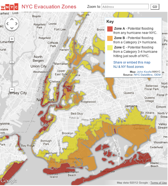
WNYC.org has a helpful map, above, that shows NYC evacuation zones. (You can also access the map directly via this link.)
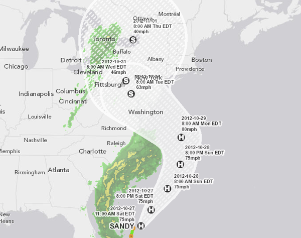
The Times has an interactive map showing the storm’s potential path.
The Associated Press has also put together a good interactive map (featured at the top of this post).
Local and federal government Web sites
Some local and federal government Web sites worth bookmarking:
Other sites and blogs
Disaster preparedness
The Weather Channel has suggestions for a disaster supply kit.
And WNYC.org has suggestions for an “urban survival kit.”
Twitter accounts and hashtags to follow
Some Twitter accounts and hashtags you might want to follow:
- FEMA: @FEMA
- The National Weather Service: @usNWSgov
- The Frankenstorm: @TheFrankenstorm
Hashtags:
Note: I’ll be posting more developments as they arise.
In the meantime, you can follow me on Twitter: @newley.