Just a quick update as of 3 p.m. Bangkok time today, October 22, 2011:
New map
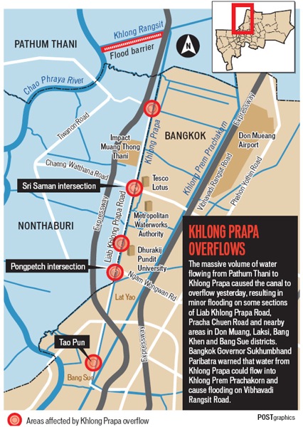
Some of yesterday’s news coverage focused on flooding caused by overflows from Prapa canal, in Bangkok’s north.
I wasn’t able to find many maps of the canal online yesterday, so I wanted to share this map, below, from today’s Bangkok Post:

The map shows, in red, the problem areas along the canal. This is the part of northern Bangkok and Nothaburi near Don Muang airport.
News reports
The WSJ has a look at the risks caused by urbanization:
Floodwaters started seeping into Bangkok Friday, as Thailand’s deepening flood crisis cast fresh light on the way rapid urbanization has increased risks for some of the developing world’s biggest cities, making them more vulnerable to natural disasters.
And:
But a rising chorus of experts says man-made factors have greatly exacerbated the problems—especially the growing concentration of people in vulnerable areas as Southeast Asia urbanizes.
In the middle of the last century, before Thailand became one of the world’s fastest-growing economies, fewer than a million people lived in Bangkok and less than 10% of the country was urbanized. Today, an estimated 12 million people live in the Bangkok metropolitan area, and more than a third of the country’s population lives in cities.
The NYT says:
Prime Minister Yingluck Shinawatra said Friday that she would take direct command of flood control in Thailand as Bangkok took the risky step of opening its floodgates and as criticism of the government mounted after days of disorganization and conflicting messages.
And:
“The real loss of the flooding is the loss of complete credibility of the Thai state in managing the kind of disaster that has occurred,” said Ammar Siamwalla, a prominent economist in Thailand who specializes in development issues.
“You must remember that this is a disaster in slow motion,” he said. “It has been accumulating, little by little, until it reaches Bangkok. It demonstrates a complete lack of infrastructure to handle the floods.”
(All emphasis mine.)
Reminder: You can read previous posts by clicking the Thailand flooding tag.
As ever, you can follow me on Twitter: @Newley.
2 replies on “Thailand flooding update October 22, 2011: Map of northern’s Bangkok’s Prapa canal”
Dear Newley: A fine series of reporting,- being away from “home” now, (BKK near the river, where else?), your work is appreciated. Thank you. JB
Hi, JB. Thanks. Appreciate it.