Categories
Thailand

Thailand flooding update: Oct. 12, 2011: Map of Bangkok flood defenses and more

This site continues to receive significant amounts of traffic from folks looking for information on flooding in Thailand.

So here’s a summary of the situation as of 9:45 p.m. Bangkok time today, October 12, 2011:

Summary

Much of greater Bangkok has not been hit by floodwaters. But there are concerns that as tides rise in the coming days, that may change.

The international airport, Suvarnabhumi, so far appears to be unaffected.

Generally, areas near the Chao Phraya river — in Bangkok and in central Thailand — are most at risk. This includes old Bangkok, downtown, near the river.

Much of Ayutthaya has been affected.

Here’s a map called “Bangkok’s Flood-Prevention Plan,” from The Nation.

You can see how authorities are dealing with the flooding here in the Thai capital:
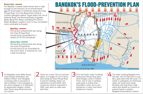
2011 10 12 bkk flooding

Here’s a larger version.

And here, again, is the map of Thailand I posted yesterday, so you can get a sense of which parts of the country have been hit:
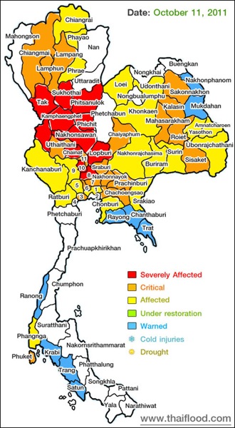
2011 10 11 thaiflood

Some news reports from today:

The WSJ describes how industries operating here have been affected:

With rescue teams and troops racing to prevent swelling floodwaters from breaching the defenses of Thailand’s low-lying capital Bangkok, foreign and local businesses continued to calculate the cost of swamped factories and broken supply chains Wednesday, while the prime minister warned retailers against profiteering.

Another WSJ story provides more info on auto makers:

Thailand’s auto exporters are being hit by supply-chain disruptions following the worst flooding the country has seen in nearly half a century.

Bloomberg says that Bangkokians have started hoarding food and water:

Thai Prime Minister Yingluck Shinawatra urged food producers not to raise prices as Bangkok residents started hoarding rice, instant noodles and bottled water amid conflicting government warnings about floods threatening to inundate the capital this week.

The AP has a dispatch from Ayutthaya:

The lucky ones traverse this flood-submerged Thai city in navy boats and motorized canoes. The rest float on whatever they can find – inner tubes, swan-shaped pedal boats, huge chunks of muddied white plastic foam.

Other resources:

Stay tuned. You can follow me on Twitter for more updates.

Categories
Thailand

Thailand flooding, Oct. 11, 2011: Map of affected areas, links to news reports, Twitter resources, and more

I’m back. More soon on where I’ve been, but for now, here’s an update on the flooding here in Thailand.

I’ve received emails on the topic, and my previous posts have been drawing a lot of traffic. So I wanted to provide a quick update.

Map of flooding

First off, here’s a map of the affected areas as of today, October 11, 2011:

2011 10 11 thaiflood

Visit ThaiFlood.com for more. It appears that the map is updated daily. (Note: It’s unclear to me how this information has been sourced, but it appears to me to be accurate.)

You can see that central Thailand, in low-lying areas near the Chao Phraya and other rivers, has been hit the hardest.

Overview

Bloomberg has the latest details:

  • This is Thailand’s worst flooding in more than 50 years.
  • 269 people have died since July 25.
  • In the last two months, floods have affected 60 of the country’s 77 provinces.
  • High tides will peak early next week — Oct. 16-18. Bloomberg reports that the areas that could be at risk then include central Bangkok; the area around Bangkok’s international airport; and areas near the Chao Phraya.
  • Various industries have been affected, as have rice farms.

Bangkok

I haven’t been down to the area surrounding the Chao Phraya river recently, but I’ve seen images from downtown Bangkok that show its waters are — expectedly — quite high. My understanding is that the areas near the river, in Thonburi and to the north of Bangkok, are most at risk.

The parts of central Bangkok I’ve seen, in addition to the southeast of the city, near the airport, are fine for now.

Ayutthaya

The BBC has a TV report on the situation from Ayutthaya.

Food, shelter, and water are on hand for those who need it, authorities say. Officials are encouraging people to evacuate when they’re told to do so, rather than staying behind to protect their belongings.

Tourism

Thailand’s Public Relations Department says:

The floods are mainly affecting land in low-lying agricultural areas and adjacent to major waterways such as the Chao Phraya River. Warnings of heavy rains resulting in localized flash floods and landslides in mountainous areas or areas adjacent to waterways have been issued for several provinces.

And:

The crest of the floodwaters is currently passing through Bangkok. Most parts of the city have not been affected, while flooding is occurring in some areas adjacent to the Chao Phraya River.

And:

All airports throughout Thailand are operating as per normal. Train services from Bangkok to northern destinations beyond Lop Buri are suspended, with only limited services in the areas affected by the flooding.

And finally:

Tourists planning to travel to the provinces affected by the floods are advised to check the latest weather forecasts for their destination and confirm arrangements with the transportation providers with which they will be travelling. Tourists can also call the TAT Information Line at 1672 to check local conditions, or visit the Thailand Meteorological Department web site at http://www.tmd.go.th/en for updated weather forecasts.

More news reports

Here’s more from The AP, Reuters, and the BBC.

A Google News search will yield additional reports.

Twitter

You can follow the Twitter hashtag #thaiflood for updates.

And a reminder: I maintain a Twitter list of Bangkok journalists, bloggers, and media folks. Many of them are tweeting about the floods.

(All emphasis mine.)